North Pine (Lake Samsonvale)
About North Pine
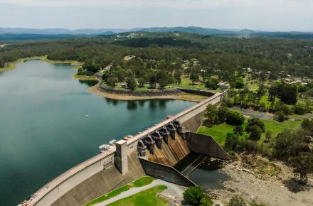
Constructed in 1976, North Pine Dam, also known as Lake Samsonvale, is built across the North Pine River, five kilometres upstream from Petrie.
North Pine is part of the SEQ Water Grid. It stores drinking water for the people of north Brisbane and Moreton Bay.
It is a gated dam. North Pine's five steel gates allow us to make controlled water releases during times of heavy rain. It's primary purpose is storing water for the people of North Brisbane and Moreton Bay. It also provides flood mitigation benefits.
Once the dam reaches its full supply level, water is discharged from the dam over the spillway. If you would like to be notified about releases from North Pine, sign up for our free dam release notification service or download our public safety mobile app.
Flood mitigation
Gated dams can mitigate flood impacts by controlling the release of water. Care must be taken not to hold back too much water and cause the dam itself to fail.
During flood events, North Pine Dam is managed in accordance with the Manual of Operational Procedures for Flood Mitigation at North Pine Dam Revision 12 (December 2023).
A controlled release of water from a gated dam will not necessarily result in downstream flooding. Once the dam reaches its full supply level, water is discharged from the dam over the spillway, which is located in the central concrete section of the dam.
The spillway is closed by five steel gates but these are opened progressively during high rainfall events in such a way to reduce the effects of flooding downstream.
It’s important neighbours and people downstream of dams know what to do in the unlikely event of an emergency. Each of our dams have an emergency action plan (EAP) in place to enable us to respond quickly to potential incidents in partnership with the Bureau of Meteorology, relevant emergency services and local councils. For North Pine Dam, this is the City of Moreton Bay.
Current capacity
On 28 January 2025, Seqwater enacted a Reduced Full Supply Level for North Pine Dam. The new level equates to a storage percentage of approximately 54% capacity. This new level will remain in place until dam improvement work is completed on North Pine Dam.
- KEY INFORMATION
- WATER SOURCE
- LIVING NEAR DAMS
-
Key information
NameNorth Pine (Lake Samsonvale)
WatercourseNorth Pine River
LocationNorth Pine River near Strathpine
Catchment area348.00km²
Length of dam wall579.00m
Year completed1976
Type of constructionMass concrete gravity and compacted fill embankment dam
-
North Pine Dam (Lake Samsonvale) is located on the North Pine River in the Moreton Bay Regional Council area. It stores water for drinking as part of the SEQ Water Grid.
North Pine has a catchment area of 348km2. The dam wall is 580m long and 40m high and can hold up to 214,302 million litres of water at full supply.
Read more about the SEQ Water Grid and how North Pine Dam contributes to our drinking water supply.
-
North Pine Dam Emergency Action Plan
During a flood event, Seqwater monitors the safety of all dams, including North Pine Dam, 24 hours a day.
Dams cannot prevent flooding from occurring altogether and in an extreme flood, there are risks that the safety of the dam could become compromised.
All dams managed by Seqwater have an Emergency Action Plan (EAP). This is standard industry practice and a regulatory requirement of responsible dam infrastructure owners, to support a quick and coordinated approach in the event of a dam emergency.
While North Pine Dam continues to operate safely, severe weather can be unpredictable and it’s important residents living near or downstream of the dam and close to Pine River familiarise themselves with North Pine Dam EAP and have an evacuation plan in place for your household’s safety.
What does this mean?
In the event of a potential or actual dam safety emergency at North Pine Dam, residents within the area will receive a text message or an automated voice message to your home phone via the Emergency Alert system.
Types of messages that could be used
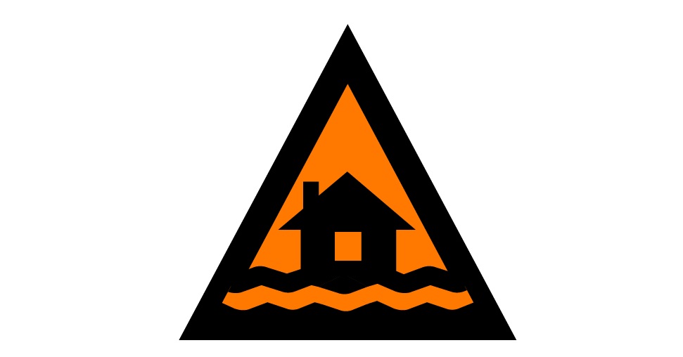 WARNING LEVEL – Watch and Act
Prepare to leaveWhat you should do:
- Prepare to leave so you can go quickly if the Pine River water levels start to rise. Get ready now.
- Decide where you and the people you live with will go if the situation worsens. Find a safe and high place away from flooding such as an Evacuation Centre.
- Warn friends, family and neighbours in the area of the possibility of flooding.
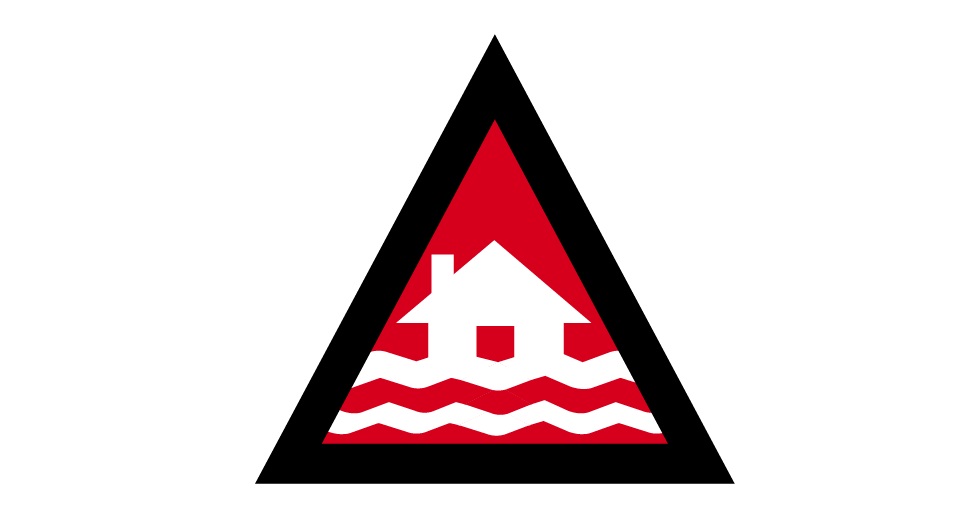 WARNING LEVEL: EMERGENCY WARNING
Move to higher ground – Dangerous flood levelsWhat you should do:
- Stay where you are and get up as high as you safely can. This could be upstairs or the roof.
- Help other people who are with you if you can.
- Tell someone where you are.
- Stay in place until you are rescued, or wait until the water goes down to safely leave.
Stay prepared & informed
In the event of a potential or actual flood emergency at North Pine Dam, it’s important neighbours and residents living nearby or downstream of this water source are aware of the flood risk and how to stay informed:
- Register for updates from your local disaster management group (MoretonAlert or Brisbane Severe Weather Alerts).
- Follow the Bureau of Meteorology for updates on weather, warnings and river levels.
- Understand your flood risk and familiarise yourself with the North Pine Dam Emergency Action Plan and ensure you have an emergency preparedness and evacuation plan in place for your household.
- Follow @Seqwater on Facebook or X (formerly known as Twitter) for dam updates.
- Download the Seqwater app or sign up for Seqwater’s free dam notification service for text, email or landline.
Download the Living downstream of North Pine Dam flyer for easy reference.