FAQs

Home Lake Macdonald Dam Improvement Project FAQs
Why does the dam need upgrading?

Lake Macdonald – also known as Six Mile Creek Dam – was originally constructed in 1965. Dams need regular maintenance to keep them in good working order and meet changing safety standards and guidelines. There have been significant advances in dam design since the dam was built, as well as new ways of estimating extreme rainfall and flood events, and a greater understanding of the size and severity of earthquakes.

This will be the first major upgrade of the dam since the wall was raised in 1980. The Lake Macdonald Dam Safety Upgrade will aim to:

  • increase the spillway capacity to safely pass all floods
  • protect the dam from overtopping in extreme flood events
  • efficiently control water flowing out of the dam to minimise flooding downstream
  • reduce risks to the dam structure during earthquakes
  • meet modern design and engineering standards
  • comply with Queensland and national dam safety guidelines.
Is upgrading the dam the best option?

More than 100 options were assessed to ensure the dam could continue to perform safely in the future, including decommissioning the dam. Upgrading the existing dam is the most cost-effective solution to improving dam safety, while also maintaining water supply and flood mitigation benefits, and keeping the lake open to recreation.

What will the dam look like?

The new dam will occupy the same footprint as the current structure, but the spillway will be wider. The new combined labyrinth and ogee spillway (pronounced O.G.) will work in a similar way to the existing spillway. When water reaches the dam’s full supply level, it will spill over the spillway. In the event of a very large flood the water will also flow over the upper labyrynth spillway and into Six Mile Creek downstream. Spillways are made from concrete and labyrinth spillways have a zig-zag shape when viewed from above.

The current earth fill embankment on the left hand side of the spillway along Lake Macdonald Drive does not meet today’s design and safety standards – that is, it is too steep and at risk of erosion. The new embankment at this location will be the same height as the existing embankment, but will be capped with rocks instead of earth to add weight and strength.

The right earth embankment on the other side of the dam's spillway, closest to the water treatment plant, will also be capped with rock to increase its stability.  

Lake Macdonald revised design 2019


When will work commence?

Work will commence on the project in late 2020 with a range of construction works including replacing the road bridge to the Noosa Water Treatment Plant and the relocation of existing utilities and services. Construction of the spillway is scheduled to commence in 2021 following the lake lowering.

Why do you need to upgrade the dam now?

Seqwater is responsible for the ongoing safety of Lake Macdonald Dam and with a growing population downstream, there are more people at risk in the unlikely event of a dam failure. The dam upgrade will allow Seqwater to improve the dam’s ability to perform during floods and earthquakes. 

Why will it take so long?

This is a major construction project and it will involve:

  • early work (such as access improvements, establishment of the site compound, internal haul roads, safety and security measures)
  • relocation and recovery of aquatic fauna before and during the lake lowering
  • temporarily lowering the level of the lake before construction begins
  • demolishing and removing the existing spillway
  • constructing a coffer dam and working platform to protect the construction area, and people working and living downstream
  • constructing concrete foundations for the new spillway
  • building a new spillway
  • reconstructing the existing earth embankments (dam walls).


Has the project been referred under the Environment Protection and Biodiversity Conservation Act 1999 (EPBC Act)? When was this done?

Yes, the project was referred to the Commonwealth Department of Environment and Energy in October 2017 and a determination was made on 6 December 2017 (EPBC 2017/8078). Final approval was provided on 7 November 2019. A copy of the decision notice is available at the Department of the Environment and Energy website. You can find the notice by searching for the referral number 8078.

Some roads in the area are narrow. Will you be making them wider?

There are no plans to widen roads for the project, however we will be looking at ways to minimise the local traffic impacts where possible such as traffic calming, reducing speed limits and restricting traffic movements to site during local peak traffic periods where possible.

Will any roads close during construction?

We do not expect any roads to be permanently closed during the construction period, however there may be temporary changes to traffic conditions at times for the safety of road users. We recognise increased traffic will  impact to residents and businesses during construction. We will be looking at ways to minimise the local traffic impacts where possible such as traffic calming, reducing speed limits and restricting traffic movements to site during local peak traffic periods where possible. Traffic management plans will be made available to the community in the lead up to construction on the project website.

How many trucks are expected during construction?

Based on our preliminary surveys, we anticipate that at the peak of construction activities, there will be up to four truck deliveries per hour during approved working hours. We will be looking at ways to minimise the local traffic impacts where possible such as traffic calming and speed limit reductions. At other times during the construction period, the amount and frequency of truck deliveries will fluctuate.

I live near the dam. How noisy will the construction work be?

Neighbours should expect increased noise at various times during construction. Construction activities will include, but are not limited to, demolition works, concrete manufacturing and pouring, rock breaking, drilling, piling, excavating and stockpiling of raw materials. Most work will be conducted Monday to Friday, however weekend work may be required at times. Working hours are likely to be between 6:30am and 6:30pm. Works may be required outside of these hours from time to time. Residents will be notified in advance of night and noisy works and we will work to minimise disruptions where possible. 

Why does the lake have to be lowered?

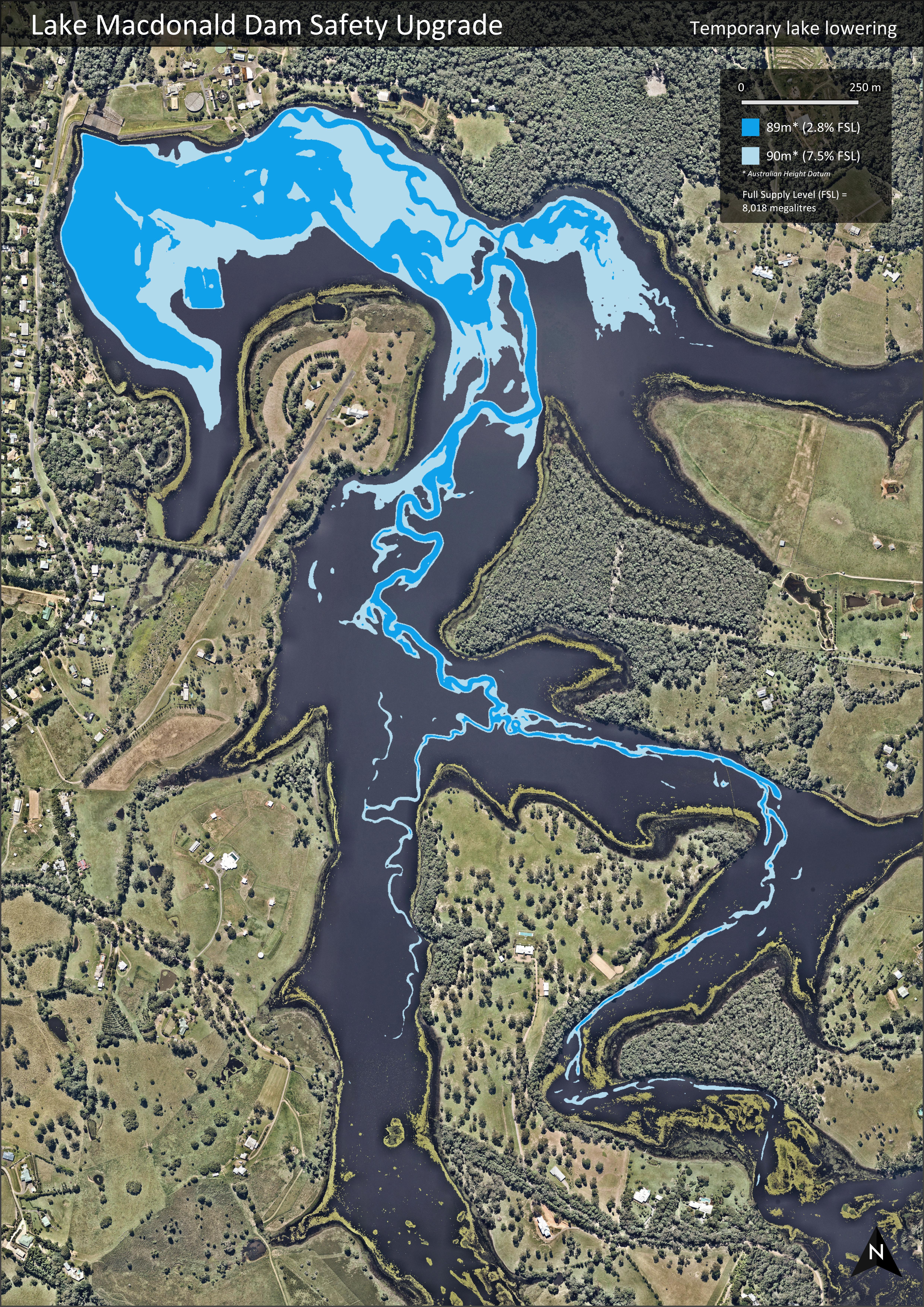
There are several reasons why we need to temporarily lower the lake level including to reduce construction risks, manage costs and, most importantly, better protect the people and properties downstream of the dam during construction. 

Seqwater assessed more than 100 options to address the dam safety risks at Lake Macdonald Dam including decommissioning the dam and building a new dam. One of the options that didn’t involve lowering the water level was to build the new dam downstream of the existing dam structure. This option was ruled out because there is very limited space available downstream to build. 

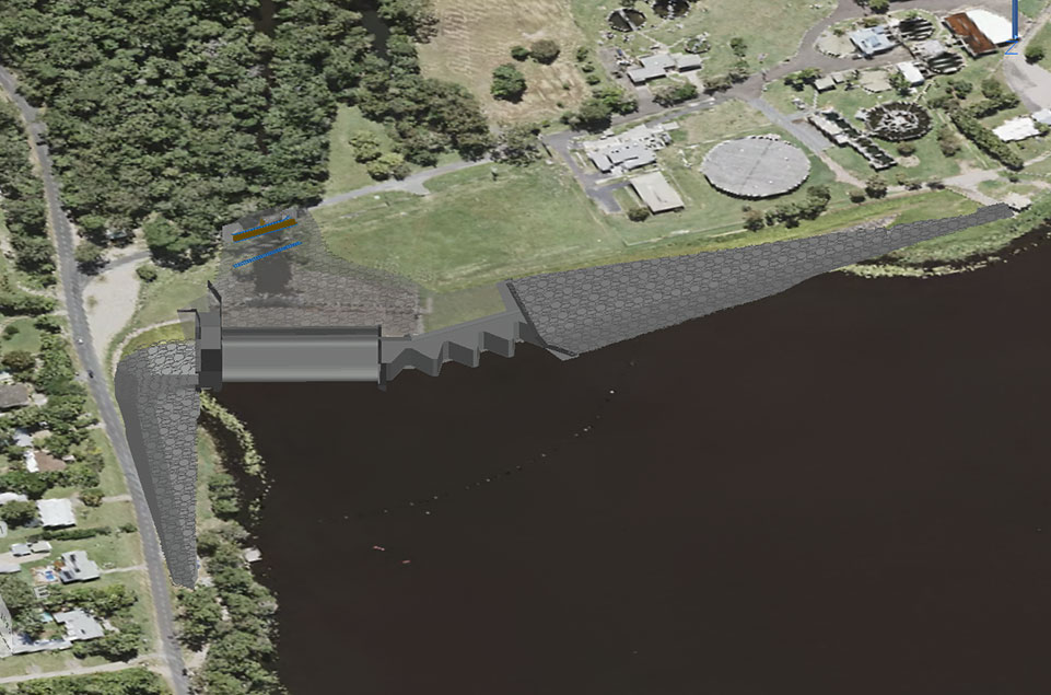
The option we have selected, to build a new dam at the location of the existing dam involves constructing a small cofferdam structure to hold back the remaining water and protect people living downstream and the people working on the dam. If we were to maintain the current water level in the lake during construction, we would need to effectively build two new dams to the same safety and engineering standards – a large temporary structure (cofferdam) to hold the water back during construction and the new permanent dam structure. Not only is this option not cost-effective, but it would result in additional impacts including dredging and disposal and more trucks on local roads to import materials. It would also mean a longer construction period.

We certainly recognise the impact the temporary lowering will have on neighbours and the natural environment so there’s a significant amount of planning we need to do in consultation with various stakeholders.

How low will the lake be? Will it be empty?

The lake will be temporarily lowered to somewhere between 10 to 5 per cent of its current full supply level(External link) during the construction period for the safety of people living downstream and working on the dam. This is about five to six metres lower than the water level is when the lake is full. In much of the upper catchment of the lake, a five to six metre lowering will result in levels like the original Six Mile Creek before the dam was built. Water levels remaining will be contained mostly to the area near the dam wall.

We recognise the impact the lake lowering will have on the visual amenity and flora and fauna in and around the lake. Seqwater will develop a comprehensive recovery and relocation plan, in consultation with key stakeholders, to manage any aquatic fauna impacted. In addition, it is expected natural streams within the catchment will help maintain water within the dam during construction.

A temporary coffer dam structure will be built to hold back the water remaining in the lake during construction. It’s important to remember this is a temporary measure for dam safety. Once the upgrade is complete, the dam will be allowed to naturally refill to its original full supply level (8,018 ML).

lake macdonald temporary lake lowering


How long will it take to lower the lake?

The lake will be gradually lowered over a three-month period, with water to be released into Six Mile Creek using pumps and possibly siphons. Water will be released at a maximum rate of 10 cubic metres per second (m3/s) to keep within the banks of the creek downstream. Aquatic species will be salvaged at various times during the lowering process.

Will the pumping to lower the lake be noisy?

The lake will be lowered gradually using pumps and possibly siphons. During the lowering, it is likely that some level of pumping will be needed overnight, and this will vary throughout the lowering process. Once the lake is lowered, there will be no need for ongoing pumping.

The project team is developing a management plan to lower the lake, which will include pumping arrangements and operating hours. We will be looking at ways to minimise impacts to local residents during the process where possible. In addition, we have conducted noise modelling in the area to understand the impact our works will have on baseline noise levels. 

I live downstream of the lake. Will my property be flooded when it’s lowered?

At this stage, we expect there should be no impact to private property or infrastructure such as roads and bridges downstream of Lake Macdonald Dam during the lake lowering. The lake will be gradually lowered over a three-month period with water to be released into Six Mile Creek using pumps and possibly siphons. Water will be released at a maximum rate of 10 cubic metres per second (m3/s) to keep within the banks of the creek downstream. More detailed information about the lowering is included in the Impact Assessment Report. To assist with the lowering process, we will also be ramping up production at the Noosa Water Treatment Plant to treat as much water as possible from the lake.

Will the odour be bad?

We expect there may be some odour generated in the lake lowering process, as sediments and aquatic plants are exposed and break down. Any odour is expected to be limited to the lake lowering phase and should not be longer than a month or two after the lowering.

How long do you estimate it will take for the lake to refill after the dam is complete?

The timeframe between project completion and lake refilling is entirely subject to rainfall and cannot be predicted. Nonetheless, Lake Macdonald has a very productive catchment and typically receives annual rainfall more than two times the full supply volume.

Where are we going to get our water from?

During construction, the Noosa Water Treatment Plant will continue to operate using water from the Mary River. The plant will not use water from Lake Macdonald while the water level is temporarily lowered. Supply will also be supplemented from other dams such as Baroon Pocket Dam on the Sunshine Coast or North Pine Dam in Brisbane using the SEQ WaterGrid(External link). The water grid is a network of dams, water treatment plants, reservoirs and pipelines that allows us to move water across the region.

What happens if it rains or floods during construction?

Low water flows will be controlled through the construction site, however larger flows may inundate the construction site. The main construction area is located at the lowest point in the river channel, which means inundation may be unavoidable at times. We will have plans in place to manage these events and protect the environment downstream.

Will the dam upgrade increase flood levels downstream?

The upgrade has been designed to maintain the dam’s current flood capacity. The purpose of the upgrade is to protect the dam structure against potential earthquakes and extreme flood events. It’s not about reducing flood levels upstream or downstream.

Will there be any water restrictions due to the dam upgrade?

There will be no residential or business water restrictions due to the dam upgrade. While the dam’s water level is temporarily lowered, the Noosa Water Treatment Plant will continue to operate using water from the Mary River. Supply will also be supplemented from other dams such as Baroon Pocket Dam on the Sunshine Coast or North Pine Dam in Brisbane using the SEQ Water Grid. The water grid is a network of dams, water treatment plants, reservoirs and pipelines that allows us to move water across the region.

Will our water cost more because of the upgrade?

No. The Lake Macdonald Dam Upgrade is part of Seqwater's capital works program, which is factored into the state bulk water charge.

How important is Lake Macdonald to the Noosa region’s water supply?

Lake Macdonald Dam is critical to the region’s long-term water security, which is why we must upgrade the dam to continue to safely supply the region with drinking water into the future. During construction, the Noosa region will be supplied with water sourced from the Mary River. Supply will also be supplemented from other dams such as Baroon Pocket Dam on the Sunshine Coast or North Pine Dam in Brisbane using the SEQ Water Grid. The water grid is a network of dams, water treatment plants, reservoirs and pipelines that allows us to move water across the region.

What happens if it doesn’t rain or there is a drought during construction?

Temporarily lowering the water storage capacity during construction will not affect the long-term water supply security in the region. We have measures in place to supply Noosa from other sources in the region during construction. The Noosa region is connected to the South East Queensland Water Grid, which is a network of dams, water treatment plants, reservoirs and pipelines. This allows Noosa to have access to water supplies from as far south as Brisbane. While water is usually sourced and treated locally, the water grid can help move water around the region when needed.

Seqwater will be monitoring the region's water storage levels before and during construction and will continue to assess scenarios to determine the best way to supply water to the Noosa Shire Council area. Seqwater has plans for managing water supply during all weather conditions, including a detailed drought response plan(External link).

I have water tanks and get water delivered to my property. Will I still have access to water?

Yes. Water delivery trucks (domestic water carriers) can continue to access Unitywater’s potable water fill stations during construction. While Lake Macdonald’s water level is temporarily lowered, the Noosa Water Treatment Plant will continue to operate using water from the Mary River. Supply will also be supplemented from other dams such as Baroon Pocket Dam on the Sunshine Coast or North Pine Dam in Brisbane using the SEQ Water Grid. The water grid is a network of dams, water treatment plants, reservoirs and pipelines that allows us to move water across the region.

What will happen to aquatic life living in the lake when it’s lowered?

Investigations are underway into the measures needed to manage aquatic fauna. Seqwater will develop a comprehensive recovery and relocation plan, in consultation with key stakeholders, to manage any aquatic fauna impacted during the lowering and throughout construction.

It is expected there will be a period when the habitat available for aquatic species, including those of conservation significance such as the Mary River cod, Australian lungfish, Mary River turtle, white-throated snapping turtle, and platypus, is limited. To minimise the impacts to these important species, Seqwater is proposing an initial aquatic fauna salvage program. We will aim to relocate all species of conservation significance before construction begins and populations of these species will be re-established in the lake after construction is completed. Some fish are sensitive to handling or changes in water temperature and may suffer injury or mortality if relocated. Therefore, appropriate measures will need to be identified and incorporated into the management approach.

Will the upgrade allow fish passage downstream?

Yes. We are looking at spillway design options to allow fish to travel downstream safely. A fish biologist has been engaged to assess the classes and sizes of fish species found upstream and provide advice for the spillway design. In addition, the project is subject to approval from the Queensland Department of Agriculture and Fisheries and the downstream passage will be subject to assessment.

Will upstream fish passage be implemented with the new dam?

The project is subject to approval from the Department of Agriculture and Fisheries (DAF).  The dam is a barrier to upstream fish passage and part of this approval includes improving the ability for fish to move through the waterway. In consultation with DAF, we are investigating both on site and off site fishway options to address the impacts of the existing dam barrier on local waterways. 

How will you prevent Tilapia from getting into the lake during construction?

The project team is discussing biosecurity issues, such as Tilapia downstream of the lake, with the Department of Agriculture and Fisheries (which includes Biosecurity Queensland). We are looking at ways to stop pest species such as Tilapia from accessing the lake during construction. 

Will fish still be stocked in the lake for recreational fishing?

There will be no fishing permitted in the lake when it has been lowered. Fish stocking will cease during the construction period and recommence once the lake level has refilled. Lake Macdonald is one of 63 stocked fishing impoundments in Queensland and will continue to be in the future.

Seqwater will be supporting the Department of Agriculture and Fisheries and local fish stocking association to restock the lake once the project is complete.

How will other wildlife be impacted?

Fauna around the lake may be affected when the water level is lowered, but most are expected to adapt to the temporary changes. For example, aquatic birdlife may seek alternative water bodies in the region with similar habitats but is likely to return once the habitat is reestablished.

How will aquatic weeds be managed during construction?

During construction, we expect the lowering will lead to a significant die back of Cabomba. We expect a period where Cabomba will be present, but the volume reduced. Cabomba (Cabomba caroliniana) is a very invasive aquatic weed, and while we have a program designed to manage infestations, there is no method to control or remove the weed effectively. We are working with the Department of Agriculture and Fisheries plant scientists and other key agencies such as CSIRO to find a biological or herbicide control agent. To manage infestations, we have a range of different measures in place including wash down facilities. We also restrict certain recreational activities on the lake to stop the spread of weeds.

We also expect to have the opportunity to tackle another aquatic weed Hygrophila (Hygrophila costata) during construction. We will continue to work with Noosa and District Land Care and Noosa Council to control this weed.

Will the lowering increase weed growth and erosion in the upstream catchment?

Lowering the lake level will expose more land in the upstream catchment and may increase vegetation including some weed species. Seqwater will have catchment management plans in place during this period and will monitor weed growth and erosion and address issues as required. It’s important we continue to work with landholders to manage the catchment, especially when the water level is lower, and encourage locals to report issues to us early. 

How much vegetation is going to be cleared?

Due to limitations at the site, vegetation clearing will be needed to make space for stockpiling and laydown areas, however it will be minimised as much as practical and limited to Seqwater’s land adjacent to the dam. Some vegetation to be cleared on Seqwater land is protected and the relevant approvals and offset requirements will be addressed before construction begins.  

Has the project been referred under the Environment Protection and Biodiversity Conservation Act 1999 (EPBC Act)? When was this done?

Yes, the project was referred to the Commonwealth Department of Environment and Energy in October 2017 and a determination was made on 6 December 2017 (EPBC 2017/8078). Due to the possibility of the project having an impact on listed threatened species further assessment is required and will be provided in the Impact Assessment Report. A copy of the decision notice is available at the Department of the Environment and Energy website(External link). You can find the notice by searching for the referral number 8078.

What ecological studies have been carried out?

A suite of technical studies has been undertaken to assess the current environment and fulfil the requirements of the Impact Assessment Report (IAR) including:

  • terrestrial and aquatic flora and fauna
  • cultural heritage (indigenous and non-indigenous)
  • traffic and transport
  • noise
  • social impact.

Specialist aquatic consultants, FRC Environment have carried out aquatic flora and fauna studies in Six Mile Creek and Lake Macdonald over the past few years to assess the current environment.

Will I still have my normal access to the lake and its surrounds?

No. Lake Macdonald will be temporarily closed to all on-water recreation while the water is lowered.

Once the upgrade is complete, Lake Macdonald will continue to be used for water supply as part of the South East Queensland Water Grid, and the lake will remain open to the public for shared recreation. There will be several parks and facilities around the lake also closed to recreation. The Noosa Trail Network will remain open, however access points to the trails will change during construction. Vehicle parking and foot access will be closed at the Lake Macdonald Drive trail head (near Kookaburra Park) and along Collwood Road due to construction activities.

Plans to provide alternative access and vehicle parking for the Noosa Trails Network in this vicinity are being worked through with Noosa Shire Council.


Where can I row or canoe?

There are alternative places for recreation available in the Noosa area including Lake Cootharaba, Lake Weyba and Lake Cooroibah. Ewen Maddock Dam and Borumba Dam (about 50km from Lake Macdonald) are other options if you’re willing to travel a bit further. The Noosa River also offers another option for water-based activities. Once the upgrade is complete, Lake Macdonald will be re-opened for recreational use.

What is happening to the Lake Macdonald Rowing Club?

The Lake Macdonald Rowing Club will not have access to the site they are currently leasing near the lake during construction. Once construction is complete, it is Seqwater’s intention to allow the club to the lease the area near the lake again.

Can I still fish in the lake?

There are alternative places for recreation available in the area including Lake Cootharaba, Lake Weyba and Lake Cooroibah. Ewen Maddock Dam and Borumba Dam (about 50km from Lake Macdonald) are other options if you’re willing to travel a bit further. The Noosa River also offers another option for water-based activities.

Where can I ride my horse or bike?

The Noosa Trail Network will remain open, however access points to the trails will change during construction. Vehicle parking and foot access will be closed at the Lake Macdonald Drive trail head (near Kookaburra Park) and along Collwood Road due to construction activities. Plans to provide alternative access and vehicle parking for the Noosa Trails Network in this vicinity are being worked through with Noosa Shire Council.

Where can I walk?

The Noosa Trail Network will remain open, however access points to the trails will change during construction. Vehicle parking and foot access will be closed at the Lake Macdonald Drive trail head (near Kookaburra Park) and along Collwood Road due to construction activities. Plans to provide alternative access and vehicle parking for the Noosa Trails Network in this vicinity are being worked through with Noosa Shire Council.

Will there be any changes to recreation once the upgrade is complete?

There are currently no plans to change recreational use at Lake Macdonald once the project is complete. However, we will be conducting an internal review of the recreation areas and facilities at Lake Macdonald during the construction period. This will involve assessing the capacity and condition of existing facilities, such as boat ramps, and what improvements might be needed in the future. In addition, there may also be works needed before the project begins to ensure access to areas surrounding the lake such as the multi-use trails.

Recreation at our lakes must be managed in a sustainable and environmentally friendly manner to ensure there are no adverse impacts on the primary role of these assets – providing a safe, secure and reliable water supply. The protection of our catchments and lakes requires careful consideration and planning. While there is always demand for increased recreation opportunities, this must be balanced with the protection of a precious resource and the ongoing provision of drinking water to a growing population.

Will the Botanic Gardens still be open for public access?

Yes. The gardens will remain open; however visitors will notice changes to the visual amenity at the lake once the water level is lowered.

I have a wedding ceremony booked at the Noosa Botanic Gardens in 2020/2021. Can this still go ahead?

Yes. Due to the lowering of the lake, there will be an impact to the visual amenity at the amphitheatre. About 30 per cent of weddings currently booked at the Noosa Botanic Gardens are to be held in the amphitheatre. If you have any questions or would like to change your booking, please contact the Noosa Shire Council at [email protected](External link) or phone (07) 5329 6500. If you are interested in booking an event at the Noosa Botanic Gardens, we recommend you contact the Noosa Shire Council beforehand. Construction activities will be conducted Monday to Friday, however some Saturday work may be required at times. It is anticipated construction noise might affect events at the amphitheatre.

Will the Noosa Botanic Gardens have enough water?

The Noosa Botanic Gardens currently uses town water. Previously the gardens did pump a small amount of water from the lake, but this is no longer the case. Seqwater does not manage authorisations to take water from the lake, this is the role of the Department of Natural Resources, Mines and Energy.

What is happening to the fish hatchery?

The Gerry Cook (Mary River cod) Fish Hatchery located on leased land within the proposed construction area will be temporarily relocated for the safety of staff and visitors. Seqwater is working with the hatchery operators, the Mary River Catchment Coordinating Committee, to temporarily relocate operations before dam construction starts in 2021. Seqwater recognises the significant conservation benefits of the hatchery and will support re-establishing the program at Lake Macdonald once construction is complete.

What is happening to the scout camp (Camp Cooroora)?

Scouts Queensland will be required to close Camp Cooroora and vacate the area for the duration of dam construction work. It is Seqwater’s intention to allow Scouts Queensland to return to the site for scouting activities once the project is complete. Safe access to the dam site cannot be maintained for scouts during dam construction due to the construction traffic movements and heavy machinery operating around the site. Seqwater and Scouts Queensland have been in discussions for some time about the upgrade project and potential for disruption. Seqwater will continue working with Scouts Queensland to make the site and buildings safe during construction.

Scouts Queensland suggests the following alternatives for bookings:

Noosa Sea Scouts Badgers Wood Campsite
Phone: (07) 5473 0028
Email: [email protected]
Address: 11 Eumundi Road
                Sunshine Coast, Queensland

Dunethin Rock Scout Camp and Water Activity Center
Phone: (07) 5446 6246
Email:  [email protected]
Address:  8 Lake Dunethin Road
                Maroochy River, QLD 4561

Rocky Creek Scout Campsite
Phone: (07) 5494 1195
Email:  [email protected]
Address: 3246 Old Gympie Rd
                Beerwah QLD 4519

Who have you talked to in the community about this project?

A Community Reference Group was established in 2015 to provide regular information and opportunities for select representatives from the local community to give feedback on project planning. 

We have engaged stakeholder agencies in various parts of project planning to date including the Noosa Shire Council, the State Department of Agriculture and Fisheries, the Commonwealth Department of Environment and Energy, and Biosecurity Queensland, as well as interest groups such as Noosa and District Landcare and the Mary River Catchment Coordinating Committee. 

We recognise there are many people living and working in Lake Macdonald, Cooroy and surrounding areas who will be interested in this project and its potential impacts. A range of opportunities will be provided as part of the project approvals process for people to access information and provide feedback on the project impacts.

Will what I say make a difference?

This is a dam safety upgrade and some aspects of the project such as the design of the dam, spillway, and associated infrastructure are not negotiable. However, it’s important we understand what the localised impacts are going to be and what you think can be done to mitigate them. We will consider all feedback, and suggestions will be reviewed for consideration in project planning and where relevant during construction. All comments received during the public notification (disclosure period) of the Impact Assessment Report have been reviewed and considered by the Coordinator General.

Where will the waste concrete from the old dam go for disposal?

The existing dam embankments and spillway primarily consist of earth fill, however there are concrete slabs on the spillway and stilling basin, as well as the outer spillway walls. The amount of concrete waste from demolishing the existing dam will be minimal and may be broken up for reuse on-site as construction material for the new dam, or potentially used for creating fish habitat in the lake.

I live beside the lake. What do I do about my animals? Do I need to put fencing up?

Seqwater understands the lowered water levels will expose mud flats for a period of time, which may put livestock at risk venturing near the lake. We would like to understand how the lowering will impact adjacent landholders and encourage you to provide feedback via the dedicated channels. 

Where will the construction crew be based?

We won’t know where workers will be based until the construction contractor is appointed. 

How many workers will be on site?

We estimate that there will be a peak construction workforce of 110 full-time equivalent (FTE) positions.

Can I get a job on the project?

Seqwater will be engaging a contractor to deliver the construction works. Employment opportunities (direct hire or subcontractor) during the construction works will need to be organised through the contractor. Contractor appointment will be determined as part of the detailed design works and construction planning. 

Will lowering the water level increase the fire risk?

Seqwater has a fire management plan and our team will inspect the catchment on a regular basis to monitor and assess fuel loads around the dam, particularly during the construction period.

Has the project received approval?

Seqwater collected feedback from the community on the potential project impacts and ways to avoid or reduce them between August and September 2018. The feedback provided informed the Impact Assessment Report (IAR), a document required by the Coordinator-General under the State Development and Public Works Organisation Act 1971. The areas assessed included, but were not limited to, traffic, noise, dust, water quality, recreation, cultural heritage, and ecology.

The public submission period for the IAR was between 11 February 2019 and 11 March 2019. The Coordinator General reviewed these submissions and approved the project in May 2019, subject to a number of conditions. The IAR document and the Coordinator General’s conditions can be located here.

In 2019, Seqwater received the required financial and federal environmental approvals to proceed with the dam safety upgrade.