Wyaralong
About Wyaralong
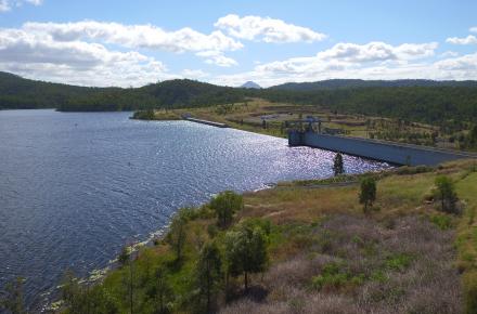
Wyaralong Dam is the newest dam in South East Queensland, completed in 2011. The lake and surrounding areas provide fantastic recreation facilities and have become a major tourism draw card for the Scenic Rim region.
Wyaralong Dam is located north-west of Beaudesert on the Teviot Brook, nestled at the base of Mt Joyce.
Just 25 days after construction finished, the region received extremely heavy rain and Wyaralong Dam began to fill. An un-gated dam, Wyaralong soon began to spill with more than 17,300 megalitres of water safely flowing over the spillway into the Logan River in the first 24 hours.
If you would like to be notified when Wyaralong Dam begins to spill, please sign up to our free dam release notification service.
For residents living downstream of Wyaralong Dam, click here to read more about how the dam has been designed and constructed, what Seqwater does to manage the dam and how the dam performed during the heavy rainfall associated with ex-Tropical Cyclone Debbie in March 2017.
Lake Wyaralong and the surrounding areas provide a great variety of recreation facilities to the local community and visitors to the region.
Download the Lake Wyaralong Recreation Guide for more information and a map of recreation facility locations.
Current capacity
- KEY INFORMATION
- WATER SOURCE
- LIVING NEAR DAMS
-
Key information
NameWyaralong
WatercourseTeviot Brook
LocationNorth-west of Beaudesert
Catchment area546.00km²
Length of dam wall463.60m
Year completed2011
Type of constructionRoller compacted concrete gravity
-
Wyaralong has a catchment area of 546km2. At full supply, the dam can hold up 102,883 million litres of water.
Wyaralong Dam was completed in 2011 in response to the Millennium Drought. It is not currently used for water supply, but could be in the future.
-
Flood mitigation
All dams help mitigate flooding to some extent. The peak outflow from a gated or un-gated dam during a flood event is less than the peak outflow that would have occurred had the dam not been built, because some water is held in the dam while it is spilling. This means that water flow slows down as floods pass through the dam.
It’s important neighbours and people downstream of dams know what to do in the unlikely event of an emergency. Each of our dams have an emergency action plan (EAP) in place to enable us to respond quickly to potential incidents in partnership with the Bureau of Meteorology, relevant emergency services and local councils. For Wyaralong Dam, this is Scenic Rim Regional Council.